Activity 2A:
SURFACE WEATHER MAPS
Do Now:
- Print this file and staple it to the back of Activity 2A handed out in
class.
- Print the Image 1 and Image 2
Files.
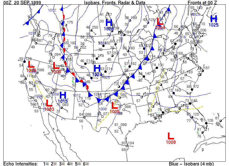
- The electronically delivered weather maps used in this course typically
have greater detail than those seen on television or in newspapers. The Monday
00Z 20 SEP 1999 (8 PM EDT on Sept. 19th) surface map (Image 1),
depicted weather conditions across the country as a large Canadian air mass
spread into the nation's midsection. The boundary of the air mass is shown by
fronts. To the east and south, the boundary is shown as a
[(warm) (cold)] front. To the west,
the boundary is shown as a stationary front.
- The wind directions within the air mass and around the elongated center of
the high pressure are generally [(clockwise and outward)
(counterclockwise and inward)].
- At map time, Chicago, Illinois, (near the southern tip of Lake Michigan
where a front symbol partially covers the station circle), the air pressure
corrected to sea level was 1011.4 mb. Chicago had other weather conditions of:
- temperature: [(61) (70)]
degrees F
- dewpoint: [(61) (70)] degrees
F
- wind direction: [(northwest)
(southwest)]
- wind speed: about [(10) (25)]
knots
and the sky was overcast (cloudy).
- At some stations, symbols for the type of weather occurring may be seen.
Green Bay, WI, Des Moines, IA, and St. Louis, MO are showing 2 or 3 dots at
the "9 o'clock" position, symbolizing [(rain)
(snow)]. Key West, FL is reporting a thunderstorm at map
time.
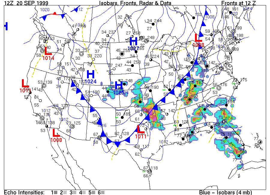
- Image
2 is the surface map for 12Z 20 SEP 1999, twelve hours after the map of
Image 1. At Chicago, IL, the pressure corrected to sea level was 1010.2 mb,
and the other weather conditions at 12Z were:
- temperature: [(53) (50)]
degrees F
- dewpoint: [(53) (50)] degrees
F
- wind direction: [(northwest)
(southwest)]
- wind speed: about [(10) (25)]
knots
- sky condition: [(cloudy) (partly
cloudy)]
- During the period from 00Z to 12Z, the conditions at Chicago changed to
having the temperature become [(cooler)
(warmer)] while the dewpoint became
[(lower) (higher)] signifying less
humid air, and the wind direction changed to become more northerly. These
changes, along with the change in the position of the front in the area, show
Chicago coming under the influence of the Canadian air mass.
The 12Z map also shows the influence of Tropical Storm Harvey in the
eastern Gulf of Mexico. Radar echoes show rain spread across the eastern Gulf
coast and the wind directions being counterclockwise and inward as with a Low.
Displaying a sequence of recent surface weather maps ending with the current
map in your classroom can show the movement of "weather makers" (high and low
pressure centers and fronts) and the changes in atmospheric conditions at your
location over time resulting from their movements. Practice looking for
connections between weather changes depicted on the map sequence and predict
local weather for the next half day or so.
Return to Meteorology
Homepage