Welcome to Meteorology. I hope the use of current weather information will become a pleasant and anticipated daily experience. I encourage your exploration of the weather products from the homepage.
The major US weather story for the week leading up to and including the Labor Day 1999 weekend was Hurricane Dennis. Dennis formed in the western Atlantic and wandered ever-so slowly northward, finally looping westward and coming onshore Saturday, 4 September, as a tropical storm in North Carolina. Dennis was responsible for tremendous beach erosion along the mid-Atlantic coast, and flooding rains across the region, some of which were welcome due to lingering drought conditions.
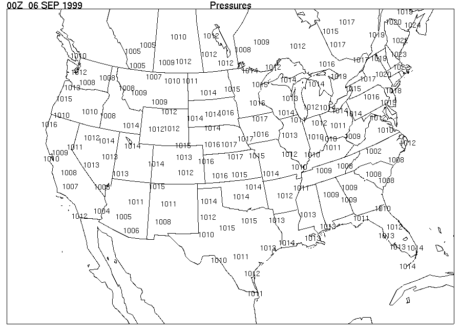
1. The Image 1 map acquired from DataStreme (identified across the top as "Pressures") displays atmospheric pressure values in millibars at ______ Z on __________________. This time is 7 p.m. CDT on Sunday, 5 September, in the central US.
2. The lowest reported air pressure on the map is
_______ mb. This was located in
[(central North Carolina) (northeast
of Maine)].
3. The highest reported pressure is _______ mb. This was
located in [(central North Carolina) (northeast
of Maine)].
4. The isobars in the conventional series that will be needed to complete the pressure analysis on this map are: 1004, _____, _____, 1016, _____. (The 1024-mb isobar would not be drawn because 1024 mb appears only once on this map, and there are no pressures above 1024 mb reported.)
This relatively small number of isobars is typical of warm
season conditions when pressure patterns are characterized by
little variation across the map area.
5. Follow the steps below to draw these isobars on this map to
determine the pressure pattern that existed at the time the
observations were made. Consider each number to be centered on
the location of that value.
NOTE: For helpful hints, refer to Tips on Drawing
Isobars
6. At map time, Dennis was a tropical depression centered near where the lowest pressure occurs on the map. The greatest pressure change over distance, or pressure gradient, on this map is shown by the isobars drawn between the center of Dennis and the highest pressure plotted in eastern Canada. Between the lowest and highest pressures on the map, _______ isobar lines were drawn. This pressure variation produced the strong, persistent onshore winds that produced the extensive beach erosion.
7. Complete the pressure analysis for the remaining portion of the "lower 48" shown. A high pressure area in the central US identifies a cooler air mass following a cold front that was expected to finally push Dennis to the east. Another lower pressure area in western Canada is associated with another cold front from the Pacific Ocean that extends to central California.
Return to Homepage