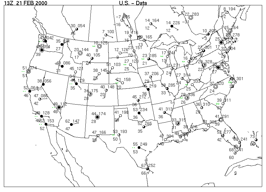
Image 1 is a map of reported surface weather conditions for Monday, 13Z 21 FEB 2000 (U.S. - Data). On this date a dramatic storm traveled across the Southeast bringing snow to the mid-section of the country as well as heavy rains from thunderstorms that produced some devastating flash floods. By the latter part of the week, fair weather prevailed over much of the eastern portion of the country under the high pressure that followed the storm system.
The weather conditions are summarized at selected stations across the US in the surface station model introduced in Activity 2A. First, examine the temperature values across the map (temperature in degrees Fahrenheit are plotted in the "11 o'clock" position about the station circle). Wichita, Kansas, where the sea-level air pressure at map time was 1021.2 mb, was reporting a temperature of _____°F, with a wind direction from the [(north) (south)] at about [(5) (15)] knots.
On the Image 1 map, use the station temperature values to draw the position of the 30 °F isotherm across the US. The isotherm would enter the US along the Montana border after beginning at Calgary where 30 °F occurred. It would then curve eastward across Montana, around to southern Nebraska, past Chicago, loop into Tennessee, and finally exit the US near New York City in its circuitous journey. Be sure to label both ends of the isotherm with its value, 30 °F. Then similarly draw the 40 °F isotherm across the US and label it.
The drawing of these isotherms reveals an important feature of the temperature pattern, called a temperature gradient. A temperature gradient is a measure of the change of temperature over distance. The gradient is relatively strong where the temperatures change rapidly over distance and weaker where the isotherms are farther apart. There is a strong temperature gradient across western South and North Dakota at map time. In South Dakota, the temperature at Rapid City (western-most station) was ______ °F while the temperature at Bismarck, North Dakota (in center of state) was ______ °F, a difference across that distance of _______ F°. This is easily seen by the isotherm lines being [(close together) (far apart)].
At this same time the temperature at Nashville, Tennessee was ______ °F. The temperature at Jacksonville, Florida (northeast corner) was ______ °F. The temperature difference between Nashville and Jacksonville was ______ F°. The temperature gradient, amount of change over distance, was weaker in the Southeastern US as seen by the isotherm lines being relatively [(close together) (far apart)] there, as compared to the Dakotas.
Where winds blow across regions of temperature contrast, cold or warm air advection occurs. Cold air advection occurs at locations where winds blow across the isotherms from regions of lower temperature to regions of higher temperature. On the Image 1 map, compare wind directions and the isotherms you drew, at stations from Oklahoma to Iowa. The wind direction at these locations was generally [(parallel) (perpendicular)] to the isotherms and from regions of [(higher) (lower)] temperatures. Warm air advection was occurring at these locations as the wind was blowing from warmer to colder regions.
Evidence of cold air advection can be seen from Mississippi to Georgia and northern Florida, where winds generally from the north are blowing across the 40-°F isotherm.
Scan the pressure values in the station models (1 o'clock position in coded values) across the eastern half of the country. The highest pressure reported on a station model is located at [(International Falls, Minnesota) (Nashville, Tennessee) (Tampa, Florida)]. Place a bold H at that station.
The circulation around a High according to the hand-twist model is [(clockwise and outward) (counterclockwise and inward)]. The wind directions in the several state area around the H you drew are generally [(clockwise and outward) (counterclockwise and inward)].
With this circulation pattern of a High, one would expect wind directions on the east side of Highs to be generally from the [(north) (south)], while the wind directions on the west side of Highs to be generally from the [(north) (south)]. Winds from the south would be expected to produce [(warm) (cold)] air advection, while northerly winds would be expected to produce [(warm) (cold)] air advection. The broad area of warm air advection you found from Oklahoma to Iowa was occurring generally on the [(west) (east)] side of the High.
The anomalously warm temperature at Rapid City, SD, at 7 AM local time, compared to surrounding stations shows the effects of a Chinook. The wind direction (southwest) indicates the wind was coming down into the city from higher elevations to the west. Such winds will be discussed in Unit 10 so get psyched!